|
INTRODUCTION :
The 'MAPtools' subgroup of the FE 'tkGooies' system is intended to
facilitate making 2D maps of several different kinds, including:
-
'outline' maps --- based on pairs of x,y coordinates ---
such as longitude,latitude pairs, in decimal degrees format
-
'image' maps, usually built up from image 'tiles' ---
available from sites such as the
OpenStreetMap.org site
-
(eventually) 'topographic' maps, with contours indicating
elevation levels above the 2D coordinates of the map
And the 2D 'MAPtools' group of utilities may eventually be augmented by
3D map-generation tools --- such as terrain generation tools --- in the
'3Dtools' menu of the FE 'tkGooies' system.
Comments on OUTLINE-DATA availability :
It is nice that U.S. government web sites (such as a plethora of
NOAA
and
USGS web sites) offer no-cost or low-cost map data that was tax-payer
financed.
BUT, their web sites and web pages and data formats
seem to go through continual 'churn':
-
web pages (that WERE sources of map data)
frequently go 'dead':
Here-today-gone-tomorrow web pages and lots of dead links
--- and a maze of menu pages, at a dizzying variety of
web sites,
Menu pages (or your 'bookmarks/favorites') leading ultimately
to lots of dead links --- making it very difficult or
impossible to find the data that you are looking for.
-
web pages (that present map data) use
more-and-more complex user interfaces:
They continually 'update' to different Javascript interfaces that
are not likely to work as intended, unless you are working on a
computer configuration (monitor and web browser) like the ones
they used to develop the web pages.
-
data formats getting more complex:
They seem to be continually migrating data to new or proprietary
(or hard-to-parse) binary formats --- and formerly available
longitude-latitude data, in simple human-readable
ASCII
(text) format, is no longer easily available.
-
favored data formats for storing map data change
almost yearly:
Multi-file government or corporate data formats keep arising, often
requiring software costing thousands of dollars in order to read
the data files.
Even ASCII/text longitude-latitude data --- which used to be
available in simple columnar format --- is being stored in
'busier' formats --- surrounded in XML-like markup language
--- such as GeoJSON and KML text file formats.
And the decimal-data-pairs are often stored in extremely long
records (in a format depending on who packaged the data),
instead of sticking to a simple 2-column ASCII format.
In short, it is a real 'slog' trying to find simple longitude-latitude
'outline' (sequence-of-points) data in a simple ASCII (text) file ---
simply containing 2 columns of decimal numbers.
For most of the 'MAPtools' tkGooie scripts that involve map
outlines, the latitude,longitude data in the input data files
are assumed to be in simple 2-column ASCII format, NOT binary.
Since map boundary/outline data is not easily found in this simple format
(any more, since about 2012), one must often find a more complex ASCII
format and 'massage' it.
Popular ASCII outline-data formats
(in the 2012-2016 time frame)
There are many country, continent, and state boundary/outline
data files on the internet in *ASCII* (text, not binary) format.
BUT the data is often wrapped in Markup Language --- in a variety of
formats within the files:
-
FROM longitude-latitude data in short records,
one data-pair per record-line
-
TO thousands of data pairs in extremely
long record lines.
Example ASCII formats:
KMZ (and KML) files seem to be many times more likely to be found
on the internet than GeoJSON files --- perhaps because they
are used with
Google Earth
(and Google Maps?) --- and with some GPS navigation devices
from various manufacturers (like Garmin).
HOWEVER, many of those KML files may be path files (or points-of-interest
files) which do not contain outline data.
Another source of ASCII map-outline data is
ESRI
ASCII
Shape Files
which are sometimes written from the complex, mostly-binary ESRI GIS
(Geographic Information System) databases.
However, it is more difficult to find ASCII ESRI Shape Files
on the internet than to find GeoJSON or KML files containing outline-data.
Most '.shp' shape files exist in a 'bundle' of files, in BINARY format.
The ESRI ASCII export files are typically named with a '.e00' suffix.
The ASCII ESRI Shape files may have the string 'ShapeFile'
(in square brackets) in the first record of the file --- but,
when ASCII shape files do exist, they may be in a zipped
(compressed) format so that the 'ShapeFile' string is not
immediately obvious.
For more information on ASCII Shape files, you can try a
web search on keywords such as
shapefile ascii export.
KML documentation
Here are some PDF files containing info on KML files:
NOT ONLY MAP OUTLINES :
(also outlines of cartoon characters,
silouettes, text, ...)
The outline data in the input files of the FE 'MAPtools' utilities
do NOT have to be latitude-longitude map data.
The data could be pairs of x,y coordinates that provide an outline
of almost any object --- for example, a person or an animal or
an insect or a fish.
OR, the data file could provide an outline of a logo --- or a
group of letters in one or more font styles.
OR, the data file could provide vertex coordinates of a
geometric figure like a pentagon or hexagon or octagon.
OR, a more complicated geometric figure could be defined by
the points in the file --- such as a fractal-like geometric
figure, like the 3rd or 4th level of a
'Koch Snowlake'.
In fact, the outline data could depict a snowflake --- or
flower petals --- or the outline of a leaf --- or the
outline of tree branches.
Use your imagination.
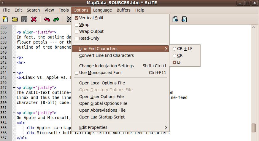
Linux vs. Apple vs. Microsoft
line-end conventions
The ASCII-text outline-data files presented here were generated on
Linux and thus the line-endings are denoted by a single, ASCII
line-feed character code (8-bit, hex '4A', decimal 74).
On Apple and Microsoft operating systems, a different
line-end convention is used:
-
Apple:
carriage-return-character-only
(hex '4D', decimal 77)
-
Microsoft:
both carriage-return-AND-line-feed characters
(hex '4D' AND hex '4A')
If you need to convert these outline-data files to a different format,
for use on these proprietary operating systems, you can probably find a
text editor that does the conversion.
Then read an outline file into the editor and save it in
the desired line-ends format.
One such text editor is the
'scite' text editor.
|